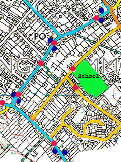
Pedestrian Crossings
Bus Routes & Pedestrian Crossing Points
Crossings
Did you know?
Many school pupils and residents commute or shop using Reading public transport buses.
Just browse:
(Courtesy : Ordinance Survey OS)
:Previous Page
"That all bus stops (4) between Westleigh Drive and Brinds Corner have suitable crossing points."
Bus Stops
Proposed Crossings
Proposal ( 7 ):
"That there be a crossing point by the Health Centre."
Proposal ( 9 ):
"That there be a crossing prior to C.Edge School."
Notes:
Restricted mobility crossing. Suggested 'raised ramp' crossing.
The Health Centre access also leads to the Sibella Way footpath and Grove Rd primary school.
Notes:
Brinds Corner and bus stop has no pavement area and pedestrians are forced to cross the road.
Kennylands Corner is a major route to Chiltern Edge school.
Note:
The pavement area stops at the Orchard Avenue junction and pedestrians are forced to cross the road.
Heavy motorised traffic congestion during school transit hours.
Alternating beacon lights suggested for peak school transit periods.
Notes:
Both entrances used by very young children on foot or scooters.
Heavy motorised traffic congestion during school transit hours.
Alternating beacon lights suggested for peak school transit periods.


:")


:")